Investigating Greenland’s ice marginal lakes under a changing climate (GrIML)
I have recently started a new 2-year project on ice-marginal lakes in Greenland, as a follow on to previous work where we derived an ice-marginal lake inventory for all of Greenland for the year 2017.
Ice-marginal lakes in Greenland
Reservoirs that form at the fringes of the ice sheet are known as ice marginal lakes. The outflow from an ice marginal lake is typically dammed or restricted, either by a moraine or by the ice itself.
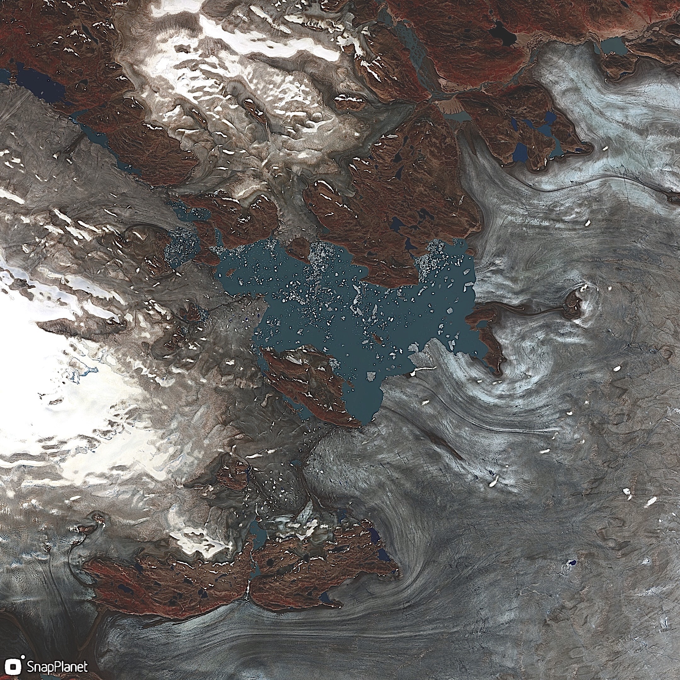
An example of an ice marginal lake in Greenland. This particular lake is an unnamed ice marginal lake (88.5 sq km according to the 2017 inventory) on the SW margin of the Greenland Ice Sheet, fed from various glacial outlets
These lakes have the potential to burst when the dam fails or is breached, causing catastrophic flooding events, which are typically referred to as Glacial Lake Outburst Floods (GLOFs) or jökulhlaups (the Icelandic term). GLOFs have been documented and studied closely at certain locations in Greenland, such as at Lake Catalina in East Greenland.
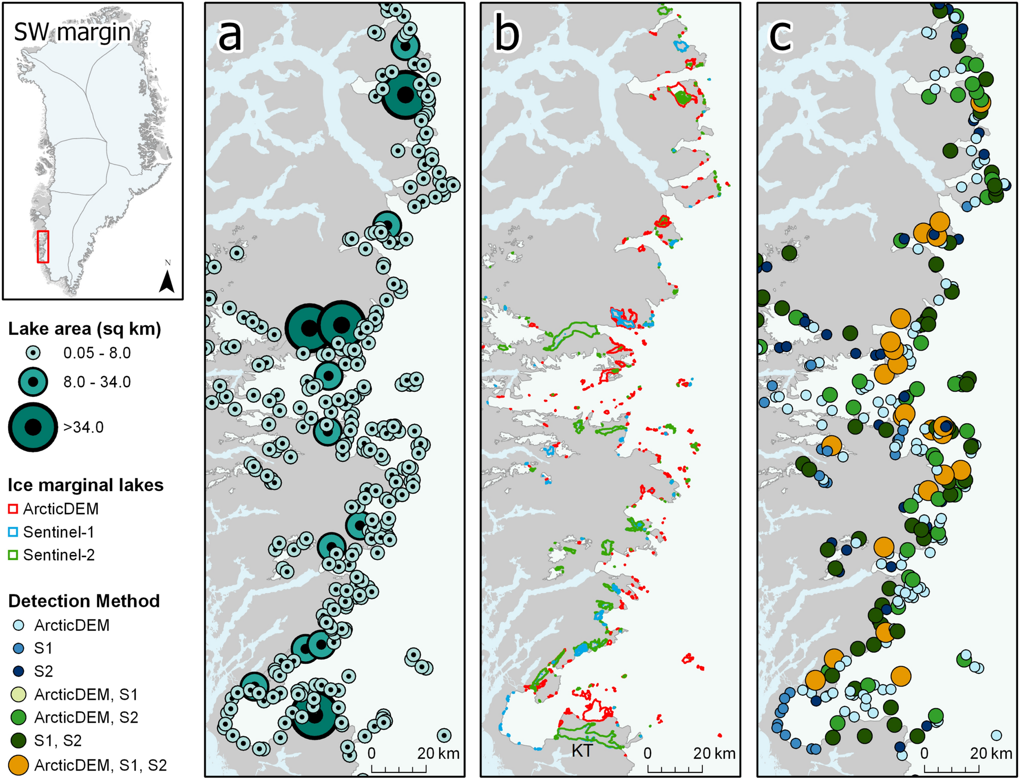
Our inventory from 2017 revealed over 3000 ice marginal lakes around the Greenland Ice Sheet and surrounding ice caps. We detected each lake using three independent remote sensing methods, utilising optical images, radar images and derived digital elevation models from satellites. In this new project, we aim to extent this study and examine ice marginal lakes in other years. With this new data, we can investigate how ice marginal lakes are changing across Greenland at a highly detailed level.
The GrIML project
Aim: To examine ice marginal lake changes across Greenland using a multi-method and multi-sensor remote sensing approach
Ice marginal lake changes will be investigated in two manners, which are differentiated by their spatial and temporal resolution.
- Annual inventories of ice marginal lakes will be generated to assess large scale changes in ice marginal lakes across Greenland (i.e. analysis covering a large spatial area at a coarse temporal resolution)
- Individual lakes will be selected and monitored more intensively over a time-series analysis to examine evolving GLOF dynamics (i.e. focused areas at very-high temporal resolution)
Programming in GrIML
GrIML will build upon existing workflows programmed in Python, refined here to form a unified processing chain that I intend to package and share openly on Github and pip.
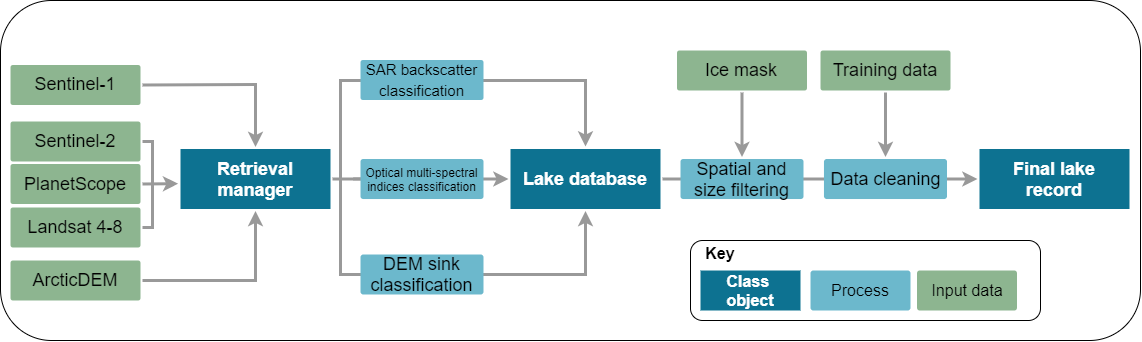
The proposed GrIML programming workflow
Key Python packages I intend to use in the workflow:
- xarray – for large data handling and parralel processing
- rasterio – for raster processing
- geopandas – for vector data handling
For the satellite data retrieval, I have a big hope to move away from heavy clunky data downloads by utilising data retrieval from URLs; using readily available functions like this. This is a big "if" though, as I am not sure how heavy this will be on computer memory.
I intend to also have an add-on module to interact with the SentinelHub APIs, a cloud processing platform that can be used to retrieve and process data from many satellite products. This should be a fun component of the project, as pushed scripts to the API are advised to be in Javascript -- a programming language I have some experience with, but want to be better at.
By having the option to retrieve data from URL or SentinelHub, I envisage that the workflow can be used by all regardless of whether they have a paid license for SentinelHub or not.