Greenland-wide inventory of ice marginal lakes published in Scientific Reports
This month we published findings from our work on Greenland's ice marginal lakes. This work are part of the ESA Glaciers CCI (Climate Change Initiative), focused on producing a Greenland-wide inventory of ice marginal lakes as a benchmark dataset; also referred to as an Essential Climate Variable. The publication is the culmination of a lot of dedicated work from individuals in the project, pooling together specialist knowledge on classifying ice marginal lakes through various remote sensing approaches.
Ice marginal lakes form at the terrestrial margins of the Greenland Ice Sheet, ice caps, and mountain glaciers, where the outflow is dammed or restricted. Ice marginal lakes can buffer the contribution of glacial melt to the sea level budget, forming a significant store of meltwater. These lakes are also understood to burst due to dam failure and breaching, causing catastropic releases of water to the ocean known as GLOFs (Glacial Lake Outburst Floods). Ice marginal lake dynamics are generally ignored in current predictions of future sea level rise, where glacial runoff assumed to contribute directly to sea level once it leaves the glacial system.

We assessed and evaluated the significance of this terrestrial store of meltwater in Greenland, using three independent and established remote sensing classification techniques to classify ice marginal lakes over the entirety of the ice margin:
- Backscatter classification from Sentinel-1 SAR (Synthetic Aperture Radar) satellite imagery
- Multi-spectral classification from Sentinel-2 optical satellite imagery
- Hydrological sink detection from the ArcticDEM (Digital Elevation Model)
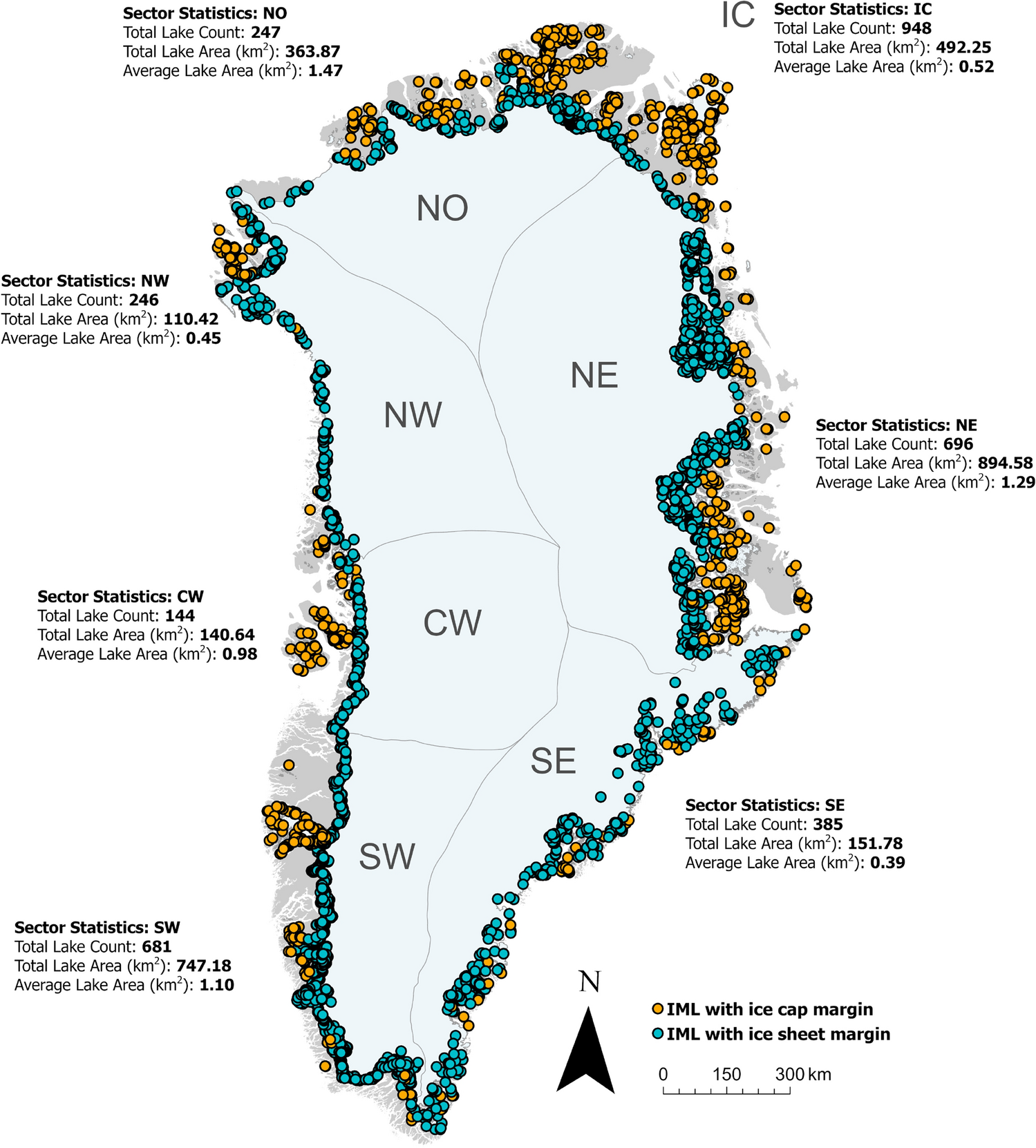
The inventory revealed 3347 ice marginal lakes (above 0.05 km2) across Greenland in 2017, with the highest number of lakes adjacent to the southwest ice sheet margin and Greenland's ice caps and mountain glaciers.
Comparison to previous work by Carrivick and Quincey (2014) suggests a 75% increase in the number of lakes along the west margin of the ice sheet over the past three decades. This trend is largely related to marked variations in the presence of smaller lakes (i.e. 0.05-0.15 km2), with future lake formation likely to be concentrated in regions where the terrestrial ice margin length will increase (e.g. where marine-terminating outlets retreat onto land).
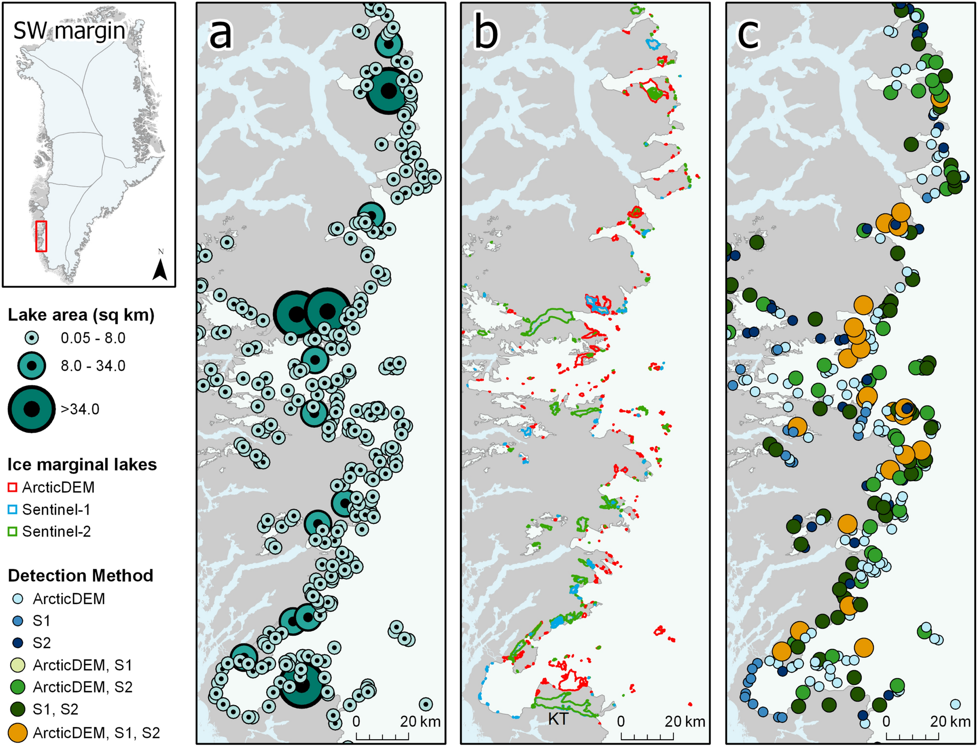
By evaluating the performance of the three methodologies used to derived the inventory, we uncovered that detecting ice marginal lakes is especially challenging in Greenland given its large latitudinal range. Water classification studies relying on a single detection method over large regions could be at risk to under-representation.

As we were writing the paper, a really nice complementary study came out by Shugar et al., (2020) presenting a new global glacial lake inventory that included Greenland. This global inventory was derived solely from optical satellite imagery, which we found only captured 44% of the lakes present in our Greenland inventory. This reflects how multi-sensor and multi-method classification are time-consuming and require powerful processing capabilities that are not feasible in global studies at present; highlighting the need to continue this research and incorporate new and innovative approaches to classifying ice marginal lakes.
Our publication is available to read (with open access) through Scientific Reports:
How, P., Messerli, A., Matzler, E., Santoro, M., Wiesmann, A., Caduff, R., Langley, K., Bojesen, M.H., Paul, F., Kaab, A. and Carrivick, J.L. Greenland-wide inventory of ice marginal lakes using a multi-method approach. Scientific Reports. doi:10.1038/s41598-021-83509-1
And the inventory can be freely accessed and downloaded through the CEDA archive.